
Use the Geoportal directly in QGIS and ArcGIS Pro
Access maps and data from the Luxembourg Geoportal in your GIS software. The QGIS plugin and ArcGIS Pro add-in let you search for a location, choose a basemap and add data to your project without configuring each service manually.
Overlay Geoportal data on your own layers and find the resources you need in a panel integrated into your familiar working environment.
Before you start
You need QGIS or ArcGIS Pro and an Internet connection to access the Geoportal’s online services. ArcGIS Pro requires a software licence.
Supported versions: QGIS 3.44 or later (also compatible with QGIS 4.01); ArcGIS Pro 3.5 or later. Check the compatibility information supplied with the downloaded package before installing it.
The English labels below match the extensions’ commands. Your software’s menus may vary depending on its interface language.
Install the QGIS plugin
- Download the plugin’s ZIP archive and keep it without extracting it.
- Open QGIS, then choose Plugins → Manage and Install Plugins.
- Select Install from ZIP, choose the downloaded archive and start the installation.
- Check that GeoportailLayerPanel is enabled in the plugin manager.
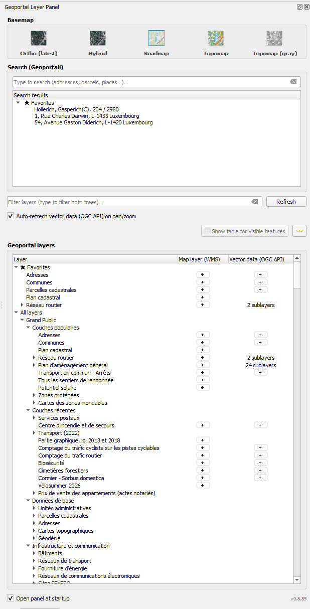
- Click the plugin icon in the toolbar or use the Geoportail Layer Panel command in the Plugins menu.
You can move the panel and dock it at the side of the window. To open it automatically whenever you start the software, select Open panel at startup.
Install the ArcGIS Pro add-in
- Download the Geoportail.lu add-in.
- If the download is a ZIP archive, extract it to obtain the .esriAddInX file.
- Close ArcGIS Pro.
- Double-click the .esriAddInX file and confirm the installation in the Esri installation utility.
- Restart ArcGIS Pro, open a project containing a map and make that map active.
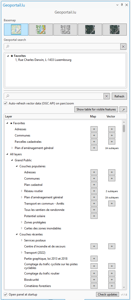
- On the Geoportail.lu ribbon tab, click Show Geoportail Pane to open the panel.
The ribbon also provides access to basemaps. The Open panel at startup option opens the panel automatically when the software starts.

Use the extensions
Both extensions follow the same approach: locate your working area, choose a basemap, then add the data you need.
1. Search for a location
Enter an address, a locality or a parcel reference in the Geoportal search field. Select the matching result to centre the map on that location. Check the full label when several results are returned.
The geographical search field and the catalogue filter serve different purposes: the first takes you to a place, while the second helps you find a layer.
2. Choose a basemap
Use the buttons in the Basemap section to choose a road map, a topographic map, a greyscale topographic map, the latest orthophotos offered by the service or a hybrid basemap. In ArcGIS Pro, these options are also available on the Geoportail.lu ribbon.
The basemap provides context for your map. Thematic layers are displayed on top of it.
3. Find and add a layer
Layers are grouped in a single catalogue, organised by theme. Each row shows the available access options in two columns: Map layer (WMS) and Vector data (OGC API) in QGIS; Map and Vector in ArcGIS Pro.
- Browse the catalogue’s themes or enter a word in its filter field.
- Expand the theme, then the layer you need if it contains sublayers.
- Click the + button in the column that matches your needs.
Choose a layer type
| Your needs | Column to use | Result | ||||
|---|---|---|---|---|---|---|
| Display a map using the cartographic representation published by the data provider |
|
|
||||
| Access geographical features and their attributes | QGIS: Vector data (OGC API) ArcGIS Pro: Vector |
Vector data supplied through OGC API Features. |
Not every layer is available in both formats. An empty column means that the corresponding option is not available for that item. A label such as 24 sublayers prompts you to expand the row and select a sublayer.
Added layers are grouped under Geoportail (Added Layers). You can then manage their visibility, order and opacity using your GIS software’s usual tools.
4. Save your favourites
To find a layer quickly next time, right-click its name and use the command to add it to your favourites. It then appears under Favorites. You can also right-click to remove it.
You can save geographical search results as favourites too, making it easy to return to places you consult regularly.
5. View attributes and metadata
To view the attributes of visible features:
- Add a vector layer and zoom to your area of interest.
- Select that layer in the QGIS layer list or the ArcGIS Pro Contents pane.
- Click Show table for visible features.
This command applies to features in the current view. It does not extract the entire dataset. A WMS layer is an image and does not provide this vector feature table.
In ArcGIS Pro, vector data from OGC API Features services is synchronised to the project’s local geodatabase (GDB). The layers added to the map use this local data. Synchronisation covers the data loaded for the working area; it does not create a complete copy of the entire service.
The Auto-refresh vector data (OGC API) on pan/zoom option refreshes vector data when you pan the map or change the zoom level.
To find a dataset’s description, provider and terms of use, right-click its catalogue entry and open its metadata using Open WMS metadata or Open vector metadata, depending on the available service.
6. Open the view in the Geoportal
Use the button for opening the current view in map.geoportail.lu to continue exploring in your browser. The viewer restores the recognised map context: position, zoom, basemap and compatible Geoportal layers.
This function does not publish your GIS project or transfer your local files to the Geoportal.
Help and troubleshooting
The panel does not appear
In QGIS, check that the plugin is enabled in the plugin manager. In ArcGIS Pro, check that it appears in the Add-In Manager, then open the panel from the Geoportail.lu ribbon.
The catalogue or a layer does not load
Check your Internet connection and use Refresh to reload the catalogue. If the problem persists, note the layer name and the message displayed.
The visible features table button is disabled
Check that a Geoportal vector layer has been added to the map and is selected in your GIS software.
How do I update an extension?
Download the new package from the link for your software and follow the installation procedure again. For ArcGIS Pro, close the software before launching the installer.
Need assistance?
Contact support@geoportail.lu, specifying your software, its version, the extension version and the steps needed to reproduce the problem. If possible, include a screenshot and the error message.